| If you do
NOT see the Table of Contents frame to the left of this page, then
Click here to open 'USArmyGermany' frameset |
|||||||||||||||||||||
USAREUR Engineer Topographic Center |
|||||||||||||||||||||
|
|
|||||||||||||||||||||
|
|||||||||||||||||||||
|
|
|||||||||||||||||||||
| ETC History | |||||||||||||||||||||
| (Source: USAREUR ETC Orientation Brochure, 1968, via Kenneth Jamin) | |||||||||||||||||||||
| HISTORY OF
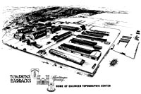
THE ENGINEER TOPOGRAPHIC CENTER (First part, not included here, covers the unit history of the 656th Engr Bn (TOPO) from activation in March 1944 to the end of hostilities in Europe, May 1945) The battalion's log for the remainder of 1945 was full. After Bobigny came Camp Twenty Grand and then departure for the US on 15 June 1945. The 656th expected a short rest, followed by assignment to the Asian theater. The surrender of Japan ruined such speculation. After five days at Camp Patrick Henry, Virginia, the battalion moved to Camp Swift, Texas, arriving on 10 August 1945. Continuing its tradition of wanderlust, the 656th moved to Camp White, Oregon, arriving in December of 1945. In April of 1946 the battalion conducted a motor march to Fort Lewis, Washington, and remained there until it was deactivated in January 1948. Most of the career topographic men transferred to the 62nd Engineer Company (Topo) (Corps) at Fort Lewis. The dormancy of the 656th was short lived. On 20 May 1949 the battalion was reactivated at Fort Belvoir, Virginia, under the command of Captain Howard J. McCracken. After more than two years of garrison duty and training, the 656th departed for Europe on 1 August 1951. Ten days later the battalion arrived at Tompkins Barracks, its present station, where it was assigned to the newly redesignated USAREUR command. |
|||||||||||||||||||||
|
|||||||||||||||||||||
| December, 1951.
The US Army Engineer Reproduction Detachment (France)( Provisional)
was activated at Schwetzingen as the 7740th Engineer Base Section
Map Reproduction Detachment. January 1952. The 656th was attached to Headquarters Company of the 7714th Engineer Intelligence Group which in turn was assigned to the Engineer Intelligence Group. On 20 August of that year the battalion received its present designation, the 656th Engineer Battalion (Topo) (Army) . 1952. The 509th Engineer Detachment (Terrain) and the 515th Engineer Survey Liaison Detachment, which later became the 515th Engineer Detachment (Topo Liaison), arrived at Tompkins Barracks. During the 1st quarter of 1952, the 23rd Engineer Map Depot Platoon and the 7740th, which would become the US Army Engineer Reproduction Detachment (France)( Provisional), moved to St Ay and Bordeaux, France, respectively, to establish depots in critical areas. 10 April 1952. Effective this date, Headquarters Company, 7714th Engineer Intelligence Group and the 656th Engineer Topographic Battalion were attached to the Engineer Intelligence Group. 15 January 1953. ETC came into being when the Engineer Intelligence Group was redesignated the US Army Europe Engineer Intelligence Center. March, 1953. The 501st Engineer Technical Intelligence Team, which would become the 501st Engineer Detachment (Technical Intelligence "Research"), was activated. |
|||||||||||||||||||||
|
|||||||||||||||||||||
| 27 April 1965.
The functions of the 501st Engineer Detachment (TIR) were transferred
to the USAREUR Technical Intelligence Center. 25 September 1965. The 23rd Engineer Platoon (Map Depot) located at St. Ay, France, was deactivated. 8 May 1967. The 524th Engineer Company (Topo)(Corps) was attached to the Engineer Topographic Center. The Company is physically located at Grenadier Kaserne, Stuttgart. 8 May 1967. The 24th Engineer Platoon (Map Depot) was attached to the Engineer Topographic Center. It is located here at Tompkins Barracks, Schwetzingen. The Cold War which threatens to ignite and the brushfire war which threatens to become world-wide in scope are a prominent characteristic of our age. Fluid world conditions often transform an area of minor significance into one of strategic value overnight. Korea, Viet-Nam, the Congo and the Middle East bear witness to this. Such global instability makes the possession of accurate, current mapping and geographic documentation paramount to national security. It is the mission of the Engineer Topographic Center to do its part within the total Department of Defense Mapping Community to provide such information. |
|||||||||||||||||||||
| If you have more
information on the history or organization of the USAREUR Engineer
Topographic Center, please contact me |
|||||||||||||||||||||
|
|
|||||||||||||||||||||
| ORGANIZATION
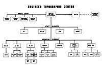
AND MISSION OF THE ENGINEER TOPOGRAPHIC CENTER The objective of military mapping and geographic documentation activities in Europe is to preserve our readiness for rapid response to the needs of U.S. and Allied Forces and to prepare in peacetime as much as possible to meet the anticipated wartime requirements. The Engineer, United States Army, Europe and Seventh Army has technical implementation responsibility for this activity, acting in behalf of the Deputy Chief of Staff for Intelligence who has the staff responsibility and budgets for the funds. The Engineer Topographic Center (ETC) fits into USAREUR as an assigned unit of USAREUR and Seventh Army Troops receiving its mission assignments from the USAREUR Engineer. In accomplishing its mission, the ETC fills three basic roles. The first is that of a mobile, Army-type topographic battalion. The 656th Engineer Battalion (Topo) (Army) provides for this directly in its military configuration. The Battalion remains at a high state of readiness for field duty, meeting all military garrison and field training requirements as well as its peacetime production assignments. The second role is that of a base topo battalion, normally located in the communications zone in support of a theater of operations. Serving in lieu of and comprising a rough equivalent to the base topo battalion is the German civilian component at ETC. These long term, highly skilled people are employed as cartographers, lithographers, and topo supply and maintenance personnel. The third role is the preparation of Engineer Terrain Intelligence documentation. This is accomplished by two TOE type Engineer Terrain Detachments augmented by professional-type American and German civilians. The Center provides control over the USAREUR theater map storage and distribution system. The management of this wide-spread complex combines features common to both the normal functions of the mobile Army battalion and the base topo battalion. The ETC data processing unit involved in the map storage and distribution function is called the USAREUR Theater Topographic Map Inventory Control Point and takes part in the world-wide map inventory control system with its main processing point at the Army Map Service in Washington, D.C. Suitable emergency plans call for a phased splitting up of the three basic roles described above into their appropriate configurations should hostilities occur or threaten to occur. A more detailed breakout of ETC is shown on the preceding organization chart. The components are narratively decribed as follows. Headquarters and Headquarters Company, 656th Engineer Battalion, is composed of a company headquarters, a Survey Platoon and battalion staff personnel. The company houses and supports the staff personnel for battalion headquarters, maintains files and duty rosters, furnishes logistical support, training and troop information for itself and attached elements. It operates a consolidated mess and motor pool for all ETC units. The Survey Platoon has three field survey parties each of which can perform traverse, triangulation, level line and plane table surveys. The Survey Platoon operates the Geodetic Control Library which receives, processes, and stores geodetic data for the USAREUR area of interest. Company A, 656th Engineer Battalion, the battalion's photomapping company, has the capability to compile original maps and map substitutes and revise existing planimetric and topographic maps and map substitutes. Operationally, the company consists of a headquarters, an operations section and a photomapping platoon having two drafting sections and one compilation section. The compilation section compiles and revises maps, and prepares photomosaics. The two drafting sections make color separation drawings by either the pen and ink method or the plastic scribing method. Company B, 656th Engineer Battalion, the map reproduction and distribution company, contains an organic reproduction platoon having camera, platemaking, layout and press capabilities using van mounted equipment. The map depot platoon, with some local national employee augmentation, operates the map depot at Schwetzingen and depots in other European areas. Attached for operational control is the 22nd Engineer Platoon (Reproduction) and the 24th Engineer Platoon (Map Depot) . The organic reproduction platoon and the 22nd Engineer Platoon print maps and related materials from reproduction materials produced within the Center or obtained from other sources. The depot platoons receive, store and issue, maintain stock records, and conduct inventories of classified and unclassified maps, reproduction materials and intelligence products. 524th Engineer Company (Togo) (Corps) is a scaled-down version of the 656th Engineer Battalion. It is physically located at Grenadier Kaserne, Stuttgart. The 524th Company has all van mounted equipment and can produce the same types of work, but in smaller quantities than the parent unit. It receives its work assignments, logistical and administrative support from Headquarters, ETC. Geographic Division. The division, headed by the senior detachment commander, consists of the 139th and 509th Engineer Detachments (Terrain), a reference library and a classified message center, Assigned military, U. S. civilian and local national personnel compile geographic documentation according to guidance received from higher headquarters and in a form suitable for cartographic drafting, reproduction and distribution. The division is capable of and has produced various types of studies, including strategic terrain studies, detailed terrain studies, tactical commanders terrain analyses, urban area studies, routes of communications studies, geological, surface drainage and river studies. Personnel also maintain basic documentation files on areas of interest. Center Reproduction Plant. This is the Center's fixed printing plant where all reproduction beyond the size limitations of the battalion's mobile equipment is accomplished. The plant employs German civilian lithographers who are skilled in all phases of map reproduction. Many of them have had continuous employment with this Center since 1948. Because of its stable and skilled work force, and its large, fixed equipment, the CRP produces approximately 75% of the unclassified printing done at the Center. In addition to its civilian lithographers, the Base Plant also has a cartographic section composed of highly skilled German civilians who greatly enhance the cartographic capability of ETC. The experience and high degree of technical skills possessed by these personnel lends itself readily to a minimum of supervision as well as an uninterrupted source of skills for unclassified projects such as city maps. Theater Topographic Map Inventory Control Point (TTMICP). This organizational segment is the initial source of supply for topographic maps within the theater. Stock control is maintained over approximately 50,000 line items of maps and related geographic materials, having an aggregate total of 40 million copies. Map requirements are computed on the basis of war plans, demands by NATO countries, and operational stock levels. Requirements are filled by printing at this Center, ordering from the Army Map Service, or procurement from NATO countries. Map requests from units within USAREUR are reviewed and filled on MILSTRIP priority basis. Automatic Data Processing Equipment is used to update map balances, conduct periodic studies on stock levels, and report transactions to the National Topographic Map Inventory Control Point in Washington, D.C. |
|||||||||||||||||||||
1975 |
|||||||||||||||||||||
| (Source: Army In Europe Magazine, August 1975) | |||||||||||||||||||||
 |
|||||||||||||||||||||
|
|
|||||||||||||||||||||
| 524th Engineer Company (Topo)(Corps) | |||||||||||||||||||||
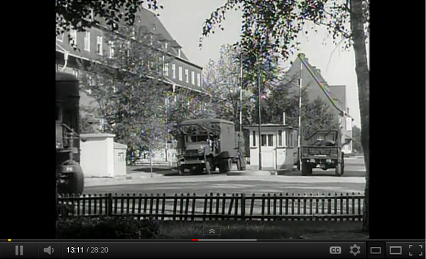 Big Picture Report #5: 524th Engr Co (Topo), 1950s (starts at 12:45 - YouTube) |
|||||||||||||||||||||
| (Source: Email from Tom Thomas, 524th Engr Topo Co, 1951-52) | |||||||||||||||||||||
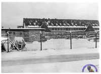
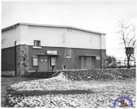
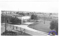
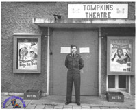
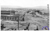
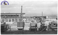
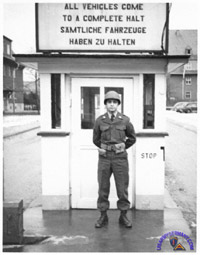
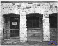
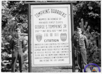
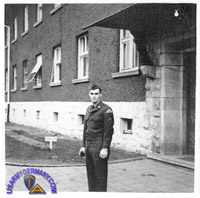
| I was stationed at Tompkins Barracks in Schwetzingen, Germany from June 1951 to Dec 1952 with the 524th Engineer Topo Co. I have been trying to find
information about our unit from that time. I am also interested in finding out what happened to the unit since then. Attached are photos of the base. The proximity to Heidelberg was a big asset for us GI's to see the historic sights and quaint shops & restaurants. Historic Heidelberg Castle along the Neckar River was always one of our stops. |
|||||||||||||||||||||
|
|||||||||||||||||||||
| Related Links: |
|||||||||||||||||||||